This the second article in a series relating the history of Lake Lanier and Buford Dam and coinciding with a special exhibit on Lake Lanier presented by the Sugar Hill Historic Preservation Society at the city’s history museum through Aug. 23.
Lake Sidney Lanier is an engineering marvel with a complex history. After much debate and lobbying in Washington, D.C., funding was approved for the construction of the almost 38,000-acre reservoir to be built on a site along the Chattahoochee near Buford. The construction phase of the dam could begin and on Wednesday, March 1, 1950, an official groundbreaking ceremony was held. escort mersin
The groundbreaking ceremony was held on the “left bank of the Chattahoochee River in Gwinnett County on a high peak overlooking the site chosen for the earth dam that would hold back the waters of Lake Lanier,” according to the book “Lake Sidney Lanier ‘A Storybook Site’: The Early History & Construction of Buford Dam” by Robert David Coughlin.
Eight men were selected to break ground on the day of the ceremony. Those men included Rep. James C. Davis, 5th District and Rep. John S. Wood, 9th District; Atlanta Mayor William B. Hartsfield; Governor Herman Talmadge; Col. Bernard L. Robinson; Cumming Mayor Roy P. Otwell; Weldon Gardner of Buford and Gwinnett County; and J. Larry Kleckley of Gainesville and Hall County. On the day of the actual ceremony, three additional men also broke ground even though they were not originally selected to do so. Those men were Eugene Hart from the Atlanta Freight Bureau; Col. J.R. Jewett, deputy chief of engineers; and Col. Walter K. Wilson Jr., mobile district chief. mersin escort
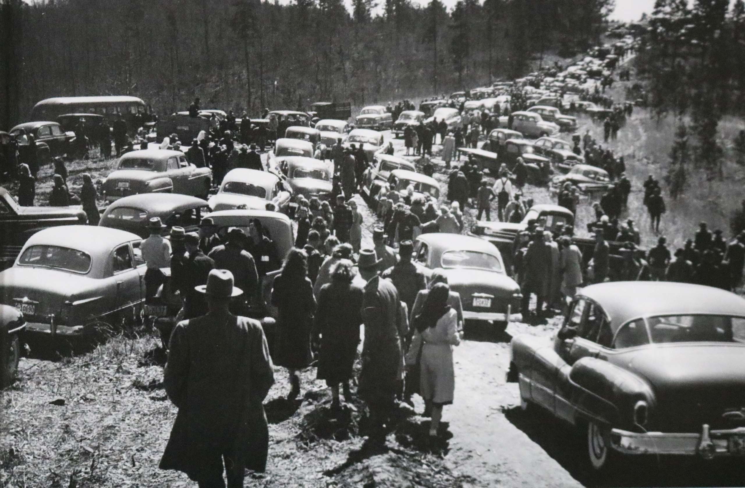
The groundbreaking ceremony was a well publicized event. Hundreds of people rode in their cars through the streets of Buford, which were decorated with flags and streamers to celebrate the momentous occasion. Everyone made their way to the site of the ceremony, although it would turn out to be anything but an easy journey. Rain the night before had turned the roughly cut construction road into a mud pit, creating the worst possible conditions for cars to travel on. Car after car became stuck in the mud and had to be abandoned.
When all was said and done, an estimated 5,000 people were reported to have attended the ceremony. They listened to speaker after speaker give remarks about the positive impact the reservoir would have on the state’s economy, which was lagging behind other parts of the country. At the conclusion of the groundbreaking ceremony, out-of-town visitors were invited to a luncheon sponsored by the Buford Kiwanis Club. The luncheon was held at a newly constructed Buford City school building on Buford Highway. Buford City Schools leveled the school building in 2007.
Construction of the saddle dikes and spillway were well underway by October of the same year. Three saddle dikes, which were like mini earthen dams, had to be constructed to hold back the water in a few of the valleys near the site of the actual dam.
Saddle dike No. 1 is located between Sawnee Campground and West Bank Park. Between West Bank Park and the actual Buford Dam sits saddle dike No. 2. The third saddle dike sits to the east of the earthen dam on Buford Dam Road between Lanier Park and Gwinnett Park. These saddle dikes, especially the third one, are not the easiest to spot as trees and other vegetation has grown around them.
The spillway allows for an unrestricted and uncontrolled flow of water to escape the lake in the event the level of the lake reaches flood stage of 1,085 feet. The spillway was constructed a mile and a half from the actual dam adjacent to saddle dike No. 3. The spillway can be best seen from Buford Dam Road as one enters a dip in the road just after passing Lanier Park heading toward the dam. The spillway structure sits off to the right and a neighborhood and power lines are on the left.
It is said that the engineers designed the spillway believing it would never actually be used. To date, the spillway has never come into service. Should catastrophic flooding occur in the watershed area of the lake, the water would move at a rapid pace down the chute of the spillway and into the low-lying areas around the spillway. Today, that would mean several neighborhoods would be impacted and homes would be flooded. The water would continue to make its way into the low-lying areas, including creeks in the vicinity like that of Richland Creek. Richland Creek eventually would return the water back to the Chattahoochee River south of Bowman’s Island.
Once the saddle dikes and spillway were constructed, work began on excavating the forebay, which is a channel that allows water to flow through an intake structure. Construction of the actual intake structure began as well.
The third article in this series on the early period of Lake Lanier will focus on the construction of the intake structure and the powerhouse.
